
Merpati
and Batavia are bankrupt; TransNusa and Garuda have cancelled all flights to Sumba. So, there are now only 2 airlines that fly to Sumba and vice versa: Wings Air ( = Lion Air) flies daily the route Denpasar Tambolaka Ende and Denpasar Waingapu Kupang. Srivijaya ( = Nam Air or Citilink) flies daily the route Denpasar Tambolaka. However, the range of flight connections and names of airlines is very dynamic.
By now flight schedules are usually respected. However due to the amount of stops throughout the day, there will be delays. Tambolaka is the more reliable airport, there are usually more than 2 planes flying to and from Bali per day. In Waingapu there is only one flight per day. And the runway is too short. At Wings Air, baggage weighing more than 5 kg is charged extra, and at Citilink, more than 15 kg is charged extra.
Online bookings direct with these airlines do work now. If you want to book via a search engine, I recommend the Indonesian search engine “Nusatrip”. Opodo or eDreams are unreliable and more expensive. The airlines do not have offices in Sumba. For Pasola or holidays planes are usually sold out.It is very important to tell the airlines an Indonesian cell phone number for return calls. A foreign mobile-phone will not be rung due to high costs.
You should take an Ojek to the airport Umbu Mehang Kunda in Waingapu, it is just 3 km. From Waikabubak to the airport Lede Kalumbung in Tambolaka it is 42 km, which takes more than an hour. From Waitabula / Tambolaka you should also take an Ojek, it is less than 3 km.
Pelni Line - runs with the ship KM Awu every 2 weeks the route: Benoa - Bima - Waingapu - Ende - Savu – Rote -
Kupang - Larantuka – Kalabahi and back again. The smaller ship KM Wilis runs
approximately the following route every week: Batulicin – Makassar – Labuan
Bajo – Waikelo – Waingapu – Ende – Kupang – Kalabahi and back
again.
You
can find the current Pelni timetable on the Internet (see information on the
link page). Pelni office in Waingapu is in Jalan Hasnnuddin at the old harbour,
phone 038761665. Pelni operates from the new harbour. Although the new harbour
is located opposite the old harbour, the overland route there is 7 km.
Sabuk Nusantara – these are various cargo/passenger ships that travel
from Sumbawa, Flores or Timor to Waingapu and Waikelo
approximately weekly. Often it is number 79 to Waingapu and number 49 to
Waikelo.
There
is no fixed timetable. There are various groups on Facebook that have
photographed and published timetables from the information boards at the
destination ports. It is unclear who the owner of these ships is. Some ships
operate under the name “Luas Line” and some have the addition of Tol Laut.
ASDP Indonesia
Ferry – with the infamous small ferries. From Waingapu it goes 2 times
per week to Aimere, 1x to the Ende, 1x to Savu, 3x to Kupang and back again. The
ferry port of the ASDP is another 2 km behind the new port (where Pelni
departs) - from town this is 9 km. From Waikelo it goes per week 3x to
Sape and back again. The Dermaga Baru in Waikelo is broken and it doesn't look
like it can ever be repaired. The ASDP's temporary dock is now in
Waikelo Harbour.
If there are high waves or any problems, these small ferries don't run - and
that's often the case. The ASDP website is abandoned. The new website Ferizy is
not working correctly yet. The ASDP can no longer be reached by telephone via
its call center 021191 or SMS center 08111021191
Private boats - for
those who love adventure:
- around
Sumba, charter boats with different facilities can be hired in Waingapu
- Kalala to Savu, 10-meter boats, sail weekly, at night time, with view navigation
- Katundu to Salura, outrigger canoes, on request or a bigger boat on Tuesdays
=
market days, 2 hours
Orientation in Sumba is difficult. This
has the following reasons:
There is no reasonable tourist map of Sumba. Supposedly accurate maps show
roads which definitely do not exist or are in different places - really
existing roads are missing. You find a collection of maps on the link
site - and, of course, in relevant guidebooks.
Online maps only work conditionally. For example Google sometimes does not recognize dusty asphalt roads, though interprets dry rivers, exposed limestone formations and even pipelines as roads. Overall, Google offers much more ways than there really are. For Wikimapia and Mapcarta, it's the other way around. In no case should you use online maps for navigation.
In
addition, online maps are not usable because of poor network availability,
especially in the countryside. The only way is to download maps before arriving
in Sumba and use them offline. The Open Street Map App (OsmAnd) with the
download for "Indonesia East-Nusa Tenggara" is the only thing I can
recommend for Sumba.
However, sometimes there are also more ways in these maps
than there really are.
Navigation in Sumba: As a supplement to this map, I have created a GPX file with more than 1100 waypoints, indication of directions and a short English description. For offline navigation with your smartphone, you can import this file preferably into the Open Street Map App (OsmAnd)
as favourites. This gives you a good offline substitute for the navigation that you can do elsewhere online using Google Maps. You can order the list also via the order-button on the feedback page.
The second reason is that places are named differently: There is the Indonesian name and its name in the particular local language. Often you find not the name of the place itself, but the name of the district (in Indonesian or local language). If you ask someone in town for a distant place, he will probably say the Indonesian name. In the place itself they only know the name in the local language.
There is also confusion due to the same name in the local language. The most impressive waterfall in Sumba is called Kanabuwai. But that doesn't really mean anything else than waterfall. And so, Google suddenly knows several Kanabuwai waterfalls. There are also several Ramuk, Waikelo, … in Google.
The Indonesian word Desa actually means village. But in Indonesia it is an administrative unit, a part of a district (Kecamatan). Because of the low population density in Sumba these "villages" have a great expansion, where the actual village (Kampung) possibly can hardly be found – or does not exist.Rivers often have as many names as areas through which they flow.
Family names change when the meaning of the name is also the description of an object (like Mr. Bridge or Mrs. Flower).
In addition there are notation changes: vowels are added, letters are doubled, endings disappear, 2 words become one...
Main roads have 2 lanes, are all paved, and in very good condition. Road damages get repaired regularly. This applies to the following connections:
- Waingapu to Napu, Baing, and Waikabubak
- Waibakul to Mamboro
- Waikabubak to Waitabula/Tambolaka, Wanukaka, and Lamboya
- Waitabula/Tambolaka to Waikelo, Kodi Bangedo, and Katewel
The remaining roads differ in their
quality. Sections are paved and super; sometimes only fragments of asphalt are
left, sometimes you go through boulder fields, beaches and river beds. The road
layout is adapted to the terrain and on steep sections it usually looks very
bad. Many recently constructed roads will only get a gravel bed first. If they
do not get paved right away, it is gone again after the next monsoon. In the
south of Sumba, there are many fords and a few bridges. In monsoon season
bikers might have to wait for a truck to take them over. Because of frequent
changes it makes no sense at this point to indicate actual road conditions. In addition,
cyclone Seroja unfortunately ripped away many roads in the southeast
(particularly all inland roads
southeast of the Melolo Ngonggi axis). What is indicated as a street on
maps or in Google may not currently exist.
Whenever I call something "Minor Road" in my
Sumba Map or Tourist Map of Sumba; 2WD drivers should ask if they could go that
way. For everything I name "Track" you will have to ask several
people what it is like and if you can make it with 4WD or motorcycle. And make a
risk assessment from different answers...
Roads, which are logical connections need not be necessarily good, it depends on ethnic connections, whether they are needed. New settlements and transmigration villages are usually completely isolated. In tourist areas it looks very different ...
The access to traditional villages is usually only possible by motorcycle or on foot.
Buses
It usually says on buses in Sumba where they go to.
Buses run generally from the vicinity of the respective markets. Only in
Waingapu there are 2 external bus terminals: one in the south and one in the
west, each about 5 km outside the town. Meanwhile nearly all busses start at the old "Terminal
Kota" in the center at the market, or from Jalan El Tari in front of it. They
probably make an intermediate stop at the outside terminals. Between
Waingapu and Waikabubak buses run almost every hour during daytime, it takes
about 5 hours. There are also small express buses, which are more expensive,
they pick you up at your hotel, do not stop on the way, and are generally
faster.
From Waingapu to the southeast, to Baing or Waijelu,
there are about 5 buses a day, which takes about 4 hours. To the northwest, to Napu
or Kadahang, there are 3 buses.
In Waikabubak, the newly built bus terminal in the Weekarou district is not in operation, buses continue to depart from the former old market in the city center. From Waikabubak to the west, buses leave almost every hour to Waitabula/ Tambolaka. If you want to continue to Pero, to Kodi or Waikelo, you should go to Waitabula and then wait for a connection. To Lamboya district in the southwest, there are 3 buses that go to Kabukarudi or maybe until Gaura. In the southern district, around Wanukaka, there are numerous buses and Bemos. Sometimes there are buses to Mamboro.
Bemos
During daytime Bemos run constantly on all shorter distances in densely
populated areas and on paved roads. Just ask where they go or look what is
written on them. Bemos are cramped and noisy. Sometimes you have to pay for
extra luggage.
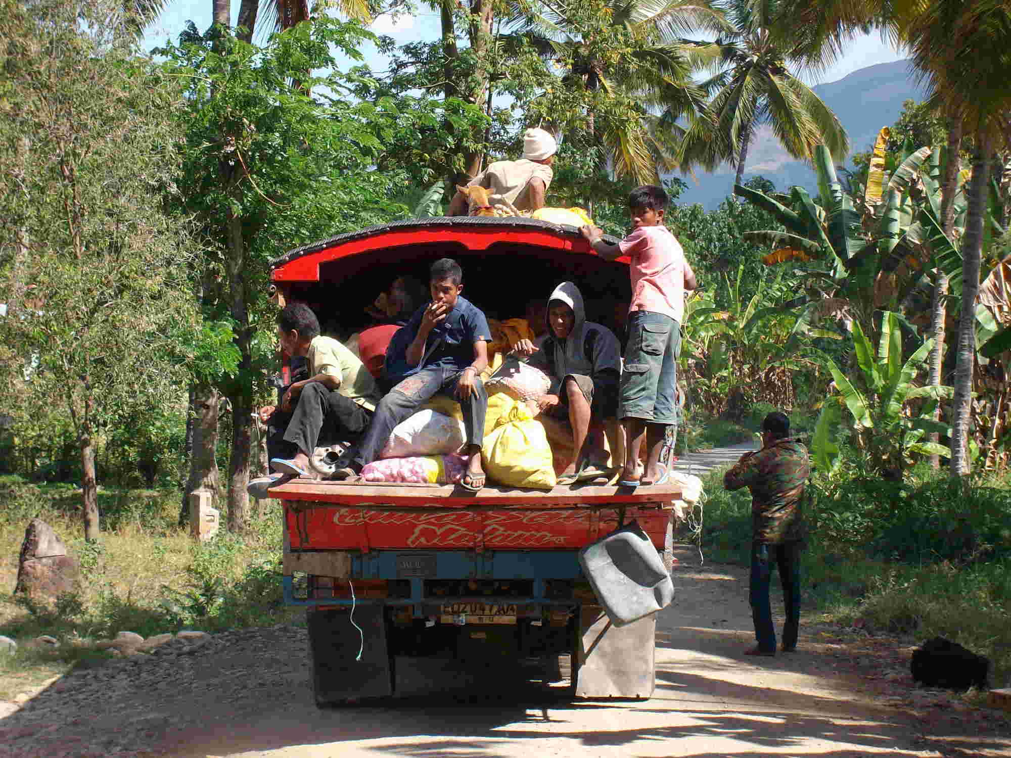
Trucks or wooden buses =
Biskayu
In all areas where road conditions are bad, you can only find trucks. Usually destinations
are painted on in colourful letters. Main routes lead from the markets in town
to places at the coast. There is next to no cross-traffic along the coasts.
On the floor of the trucks, there are wooden benches transversely installed. Some trucks are open. It may happen that you have to share a bench with a Sumba horse. If you want to go to Tarimbang, Tawui or smaller towns at the north or south coast, you are dependent on trucks. Travelling is painfully slow on the eroded roads...
Currently the trip from Waingapu to Tarimbang takes meanwhile about 4 hours. From Waingapu to Tawui the trip takes meanwhile 9 hours in dry season and much longer during monsoon season.
Collective Taxis
At bus terminals, ports, and airports are often unofficial collective taxis
available. The price depends on the number of passengers. These collective
taxis usually go only to the larger places. For smaller places they do not get
enough passengers.
If there is no public transport, take an
Ojek = Motorcycle Taxi,
or rent a Car
For
short distances you will almost always take an ojek =
motorcycle
taxi. The
backpack is put between the handlebars and the driver, then just sit down
behind him and off you go. A helmet is not compulsory out of town.
If you do not know the usual price, you have to negotiate beforehand. For long distances on poor roads, the price will be quite high (Bali is not a comparison). You are quite likely to have to help the driver to push the motorcycle.
Anyone travelling with a suitcase on wheels or more across the country, has no alternative than to rent a car. Car rental is extremely expensive due to road conditions, and because there are only a few suppliers. Depending on the specific road conditions half up to one million rupees a day with driver and gasoline is reasonable.
You can rent a motorcycle everywhere. If you rent one from your hotel, the owner of the motorcycle gets only about 2/3 of the rent.
To hire a private motorcycle requires some knowledge of language on both sides. The price for a private motorcycle is mainly influenced by the impression which the owner has of you. After all, it's his bike that you might break. Expect about 3 times the price of Bali.
A fully automatic motorcycle, as it is often offered in Bali, is not suitable for Sumba. Motorcycles with surfboard racks do not exist. You must be aware that you must often drive up on steep gravel roads, through rivers and rough terrain. Honda Revo is the common motorcycle in Sumba.
Many owners require no deposit - a handshake is all. I consider it is important in the mutual interest, to give the owner, for example an ID card or an ATM card. In addition, you should definitely write down the cell phone number of the owner to give information in case of breakdowns, problems, and to keep up SMS contact during longer trips.
The facilities of a motorcycle should
include:
- 2 functioning brakes
- Normal standard tyres with tread
- Electric starter
- Well-fitting, lubricated, and smoothly running chain
- Light
- Helmet
- License plate, license (Surat Mobil) or proof of purchase
- Proof of paid tax
- Tools, especially for tyre changes (open end wrench 10-17 and 19 ring wrench)
This you should be bring with you for
longer and off-road trips:
- Repair kit (usually do not last long, there are no self-adhesive patches in
Sumba)
- Spare tubes (front and rear different, universal tubes do not last long)
-
Tire pullers and lubricant (or shampoo) for tire
changes
- Foot pump, quality bicycle pump or electric pump (if you like to boast)
For Indonesia, you need an international driver's license - but no one knows that in Sumba - all Indonesian children drive motorcycles when their arms and legs are long enough.
At the main road Waingapu, Waikabubak, Waitabula, and Melolo there are now many gas stations and an increasing number of private fuel pumps. Apart from this route you have to rely on gasoline in bottles.
By the length of the queues at the pumps you can get an idea about the gasoline supply. It often happens that a tank ship is late and then there are bottlenecks. "Bensin habis" can be read sometime at the gas stations. The only port for tankers is in Waingapu so the gasoline supply is often not backed up in West Sumba.Sumbanese know that, and are hoarding
gasoline. Gasoline is more expensive and rarer to get, the further you are away
from a gas station, on Sundays, and when a petrol price increase is pending.
If you drive through uninhabited areas in
East Sumba, you must be able to repair tires and chain yourself and carry
sufficient fuel and drinking water.
Except in the cities you hardly get spare parts.
Renting cars without a driver may be possible only at both airports. Since sometimes there are people who lend their cars privately. However, anyone who borrows something like this is bound to paved roads.
Due to many requests from readers I've looked around during my last visits in Sumba whether there are places for riding. Usually people gave a negative reply. Only Philip Renggi, Sony Radjah, and Yuliana Ledatara (cf. below), were interested to this subject.
Nothing is offered in Sumba, you just have to ask. There are no special tours or routes, only small narrow paths from village to village and back again, or along the beaches.
At following places or beaches riding is possible on request: Kambera, Kalala, Melolo, Tarimbang, Katikuwai, Tawui, Wanukaka, Kerewe, Mamboro and around Waikabubak. Just ask locals.
Regular races take place at the Pasola places and at low tide on the beaches such as Melolo, Tawui, Wanukaka and Rua. Partly it is training for the Pasola; partly it is a sporting showdown among the village youth.
Due to the fear of the Surra horse epidemic, there are currently few ridings offers.
For the people of Sumba trails and paths are connections between their villages, to water holes, the fields and the next road. As mentioned before there are clear ethnic boundaries between settlement areas.
Destinations for trekking are beaches, waterfalls, mountain peaks, and jungle. Therefore it is not easy to find a guide who can really help you. Actually you need several guides: one who translates, one who knows the region as a whole, and one who knows about nature and landscape.
Particularly in densely vegetated areas of the south you are dependent on a guide. Many routes are rarely used; they are often overgrown and therefore difficult to recognize. Paths of people (jalan orang) are difficult to distinguish from livestock paths (jalan hewan). Locals also know about boars, snakes, and crocodiles.
In the arid north it is easier, but many things can simply be overlooked. The traditional village of Prailiang for example, is so embedded in the landscape that you only notice it because of the noise of children.
Trekking in Sumba is possible - but trekking is something locals do not do. A trekking foreigner without a guide is entirely self-responsible. For help in an emergency case you have to take care of yourself.
Trekking tours that I have described in this website are mostly demanding. Only some of these tours I have done myself.
![]()